


Today sees the start of the Long Jump which encourages pilots to make a flight a bit longer than they are used to. It’s a good thing to step outside our comfort zone sometimes and when you read the reports posted about flights made in previous years you will surely be inspired to seek that great adventure for yourself.
Good luck, have fun and be safe.
Robin.
BBC Weather……
Tuesday 30 September to Sunday 5 October
Wet and windy at times, especially on Friday
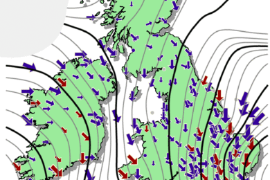
A sequence of fronts and low pressure systems will pass across the UK through the rest of this week. Southern England will be largely dry on Wednesday, while early rain elsewhere will ease. However, another dose of wet and windy weather will follow on Thursday, starting across Northern Ireland and Scotland then erratically spreading across the rest of the UK.
South-east England will be dry for much of the day, but rain will arrive in the evening or overnight as a ridge of high pressure retreats and allows a front to move through. The strongest winds will be across western and northern regions.
Hard on its heels, another frontal system will arrive on Friday, attached to a potentially potent low pressure circulation approaching western and northern Scotland, where it could produce severe gales. This system will have the remnants of Hurricane Humberto wrapped up in it, and the rest of the UK will see strong winds developing, reaching gale force in some exposed areas, with heavy rain steadily advancing eastwards.
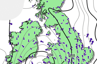
Although this low will move away eastwards, it will leave a blustery weekend with fresh to strong winds and sharp showers scattered around, while northern and western Scotland see some steadier rain. In between the showers there will be spells of sunshine, with the best of them in southern and eastern England, which will see the fewest showers.
Conditions should gradually calm down through Sunday. It will turn cooler, but temperatures will still be near the early October average.