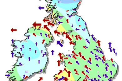
Wet and windy at first in the northwest of the UK, but rain and wind easing through the afternoon. Largely dry elsewhere with sunny spells developing, mainly in the south and east. Feeling warm in the sunshine.
Weather Warning
Issued by the Met Office
YELLOW WARNING of WIND for Scotland, Northern Ireland, Northwest England, Wales and Southwest England.
Updated 13 October at 10:30
Valid from 12:00 on Mon 16th to 23:55 on Mon 16th
A spell of very windy weather is likely on Monday in association with ex-Ophelia. Road, rail, air and ferry services may be affected, with longer journeys times and cancellations possible. Power cuts may occur, with the potential to affect other services, such as mobile phone coverage. Some damage to buildings, such as tiles blown from roofs could happen, perhaps leading to injuries and danger to life from flying debris. Coastal routes, sea fronts and coastal communities may be affected by spray and/or large waves. The warning has been updated to delay the onset time of the strong winds and increase the likelihood of the event occurring.
Very strong winds are forecast to affect western parts of the UK during Monday. Southerly winds are most likely to gust between 55 and 65 mph across much of the warning area with the potential for gusts of 80 mph in coastal areas, particularly in Northern Ireland. These strong winds are forecast in association with the northward track of ex-Ophelia across or near to the west of the British Isles. Heavy rain is also possible in association with this system with northwestern UK most prone at this stage.
YELLOW WARNING of WIND for Scotland, Northern Ireland, Northwest and Northeast England.
Updated 13 October at 10:30
Valid from 00:05 on Tue 17th to 18:00 on Tue 17th
A spell of very windy weather is likely on Tuesday in association with ex-Ophelia. Road, rail, air and ferry services might be affected, with a slight chance of longer journeys times and some roads and bridges could close. There is a slight chance that power cuts may occur, with the potential to affect other services, such as mobile phone coverage.
Very strong winds are forecast to affect northern parts of the UK during Tuesday. Southwesterly winds are most likely to gust between 50 and 60 mph across much of the warning area with the potential for gusts of 70 mph across the Central Belt of Scotland and parts of Northeast England. The strongest winds could potentially coincide with the morning rush hour. Heavy rain is also possible in association with this system with western Scotland most prone at this stage.


